-

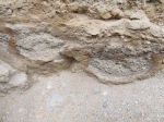
- The surface of the temples BEFORE excavation.
-

- Protective measures taken by PANC in 2007 included topping the architecture with loose sediment and covering the adobe walls with stone retaining walls.
-

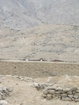
- The water level has been exceptionally high in the irrigation canal this year.
-
- The Leica Total Station on its perch atop the Main Mound at Huaricanga.
-
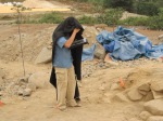
- Carlos taking points using the Total Station stadia rod.
-

- This is called a Triangulated Irregular Network or TIN which means there are little triangles placed over each elevation point to create a 3D mesh. Note the temple-like structures in the middle-right.
-
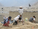
- Archaeological excavation is a tedious process best accomplished (in most cases) with trowels that are used to slowly peel away layers of history.
-

- Most artifacts are not found in situ (i.e. in the place in which they were actually used). In fact, the majority of the materials that are recovered are found in the screens.
-
- Context is everything in archaeology. Therefore, in order to ensure that the provenience information is accurately recorded it is immediately written on every bag of artifacts.
-

- We use this 10 ft. ladder to obtain accurate overhead photos that minimize distortion. Maneuvering this behemoth over an archaeological site with its delicate walls and floors is quite the process.
-
- Overhead images are digitally stitched together and then traced to create maps. Here I am demonstrating the drawing process with a tablet PC and “hood” to better see the screen. Drawings are completely in the field to get a better glimpse of the finer details of rocks and stains.
-

- The floors that we expose from these early temples often feature 2-3 layers that represent 1-2 base layers or “falso pisos” (false floors) plus a final coat of plaster. We often find hand prints and footprints in these “falso pisos.”
-

- A 5,000-year-old footprint in a “falso piso.”
-
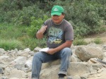
- Any good director knows how to supervise.
-

- We’ve finally reached the temple structure we targeted in the profile!
-

- A block of archaeological sediment encased in plaster. This sample will be impregnated with resin and sliced into thin sections. The thin sections will then be viewed under a microscope to see the micro-stratigraphy in a technique called micromorphology.
-

- Here I am using the Total Station to map exactly where we take samples for XRF analysis. Using these location points we can construct accurate maps of floor surfaces with elemental concentrations measured during the chemical analysis.
-

- A GigaPan robot was used to remotely take high-resolution images of a profile. The workers have never seen such a robot, so it was obviously all the rage at the dig!
-

- HARP opened up a 2 m x 6 m trench originally excavated by PANC in 2007. The objective was to dig below the earliest occupation to find out how long ago people lived at the site. As you can see here, the lowest levels consisted of small rooms (2 m x 2 m) quite unlike the temples above.
-
- We proceeded farther down and found layers of domestic trash including stone tools used for preparing food, hearths used to cook, and plenty of kitchen garbage such as shells, seeds, and ash. Therefore these spaces were domestic in nature, not ceremonial.
-
- In the profile of a lower level we discovered these beautiful fogons, or hearths. Food was prepared in each hole and the fire hardened the sand below and turned it red. Each hearth was sampled for pollen and fine screening to find out what foods were prepared inside them.
-
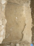
- In one excavation unit, an amplification of our original 10 m x 10 m grid, we uncovered a beautifully preserved temple floor at the bottom of the stratigraphic sequence. You can see the niched wall on the bottom right corner of the photo.
-
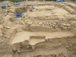
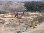
- This photo, taken from a 15 ft ladder, provides a general view of the site midway through excavations. In the background you can see the larger temple with its two access points and in the foreground, closer to the canal, is an earlier temple with a two-level floor.
-

- This early temple with two level floor was the target of the 2012 HARP excavations. The structure was built in three construction phases. Each phase, indicated by the colored lines, reveals that over time the sunken space became smaller and smaller thus accommodating smaller and smaller groups of individuals in the ceremonies that took place there.
-
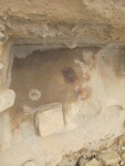
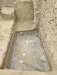
- The lowest and thus earliest floor of the field season. Although only a small fragment remains, it was well-preserved with evidence of at least two burn events with a high temperature fire (the intense coloration). The lower portion of the two-level floor is clearly visible in this photo.
-

- The final group photo of the field season. Thank you to all of workers and especially our co-director Carmela for your help and guidance all summer long!
-
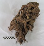
- After the field season begins the laboratory period. Here we inventory all of the artifacts and analyze all of the recovered remains such as botanics, lithics and shell. Here is an intact woven bag made of plant fibers. Such bags, called shicra, were filled with rocks and dirt and used as construction fill during the Late Archaic Period.
-
- After returning to the field to dig one last test pit we cleaned out a looter’s trench in order to look for buried architecture. To our surprise we encountered a burial! Here you see the circular form of the burial with two foot bones in the bottom right of the photo. Note the lens of gravel around the edges of the circle. That is the matrix, or clean sediment around the burial itself that often indicates that someone was buried here.
-

- After finding the burial, we amplified an earlier test pit to look for more buried architecture below the large temple. About 1.5 meters below the upper temple we encounter the corner of a large wall with two smaller walls as well as two floors. This architecture was likely related to the structures of a domestic nature in the adjacent trench begun in 2007 and dug to sterile by HARP in 2012.
-

- As we dug out the construction fill that lay on top of the buried architecture in the amplified test pit we encountered ancient trash such as fish bones, lithics, shell, and this gourd or “mate.” The Late Archaic (3,000-1,800 B.C.) is also known as the Late Preceramic because the time period pre-dates the introduction of ceramics in the Andes. Gourds would have been used as storage vessels and this is a beautifully preserved example of one.
-
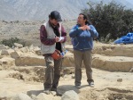
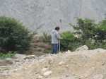
- After excavations are completed, an inspector from the Ministry of Culture visits in order to make sure that we’ve worked within our permit guidelines and are taking steps to preserve the site.
-
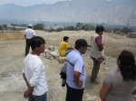
- Community engagement is an important aspect of archaeology. The local community is currently constructing a water reservoir in a sunken circular plaza. The Ministry inspector is responsible for informing the community about their rights and a proper course of action.
-

- Our lab facility at Barranca is fully equipped with microscopes, lights, and storage space for all of the excavated materials. Here, the workers are already beginning analysis of botanical and shell remains.
-

- Thanks to funding from the Field Museum’s Women’s Board and their Field Dreams program, we’ve been able to purchase this new microscope to study use wear on the edges of lithics.
-

- Possibly a new stone tool type! We found several of these triangular-shaped choppers with a retouched edge during our excavations.
-

- Conducting XRF analysis at the Field Museum’s Elemental Analysis Facility.
-
- The radiocarbon samples all packed and ready to ship to the NSF AMS Radiocarbon Analysis Lab at the University of Arizona.
-
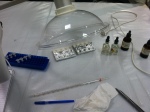
- Solvents are used to dissolve the compounds. Here you see all of the materials used in the preliminary steps of FTIR analysis.
-

- JP Brown looking at possible organic compounds under a microscope.
-

- Can you detect the residues? Unless you have microscopic vision, probably not.
